
Significant Severe Weather Event Looms for Tampa Bay Region on Tuesday

By Tampa Bay Living Magazine staff
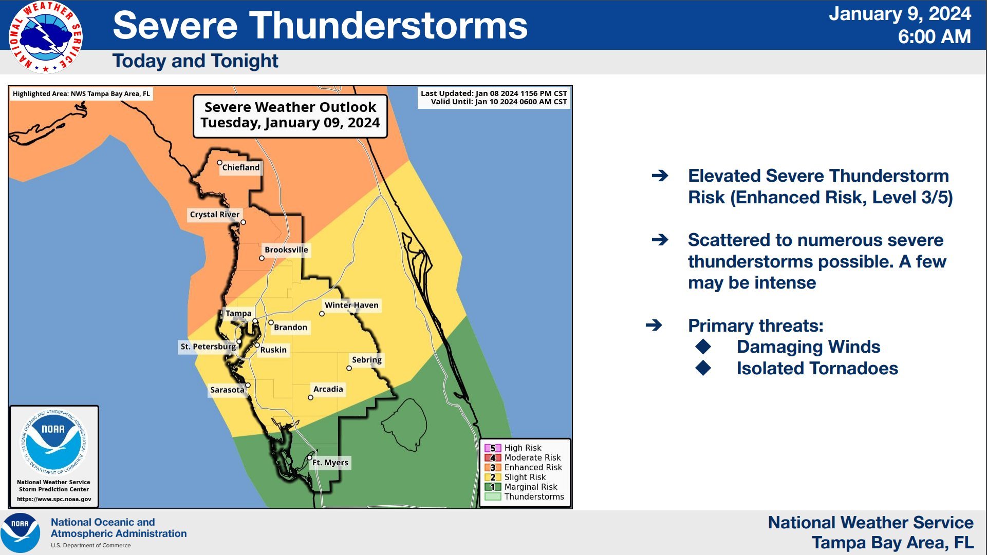
UPDATED 9 a.m.: According to the National Weather Service (NWS), parts of the Tampa Bay region are now under an enhanced risk (3/5) and a slight risk (2/5) for severe storms on Tuesday. This means damaging winds (60–75 mph+), several tornadoes, including a couple strong tornadoes (EF2+), and large hail are possible through Tuesday evening. Stay tuned to Tampa Bay Living Magazine for updates.
Residents of the Florida peninsula and the Tampa Bay region should brace themselves for a major severe weather event on Tuesday, according to weather experts. A swiftly moving line of thunderstorms is moving across western parts of the Florida Panhandle, Southern Georgia and Southeast Alabama. Early reports from Panama City officials say there is “significant damage” in Panama City Beach area after tornadoes swept through the area.
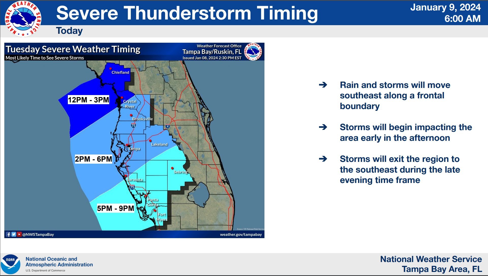
According to Tampa Bay NWS Meteorologist Paul Close, the timing of the storms in the Tampa Bay area will vary depending on residents’ and visitors’ locations from north to south. Generally, the storms are expected to come through during mid-afternoon on Tuesday and continue until early evening, starting at 2 and 3 p.m. and lasting until 6-7 p.m., according to Close.
Weather experts say these storms are predicted to pack quite a punch in the Tampa Bay region, with damaging winds (60–75 mph or greater) likely to occur with this system.
“My greatest concern for Tampa at this time are the damaging winds potentially embedded along the leading edge of this front as it barrels through. Frequent cloud-to-ground lightning can also be dangerous and create power outages along with high wind speeds,” said David Nazario, a former U.S. Air Force weather forecaster and analyst, in an interview with Tampa Bay Living Magazine. “Localized flooding is on the table because of the rain rates we'll see in our heaviest convective bands.”

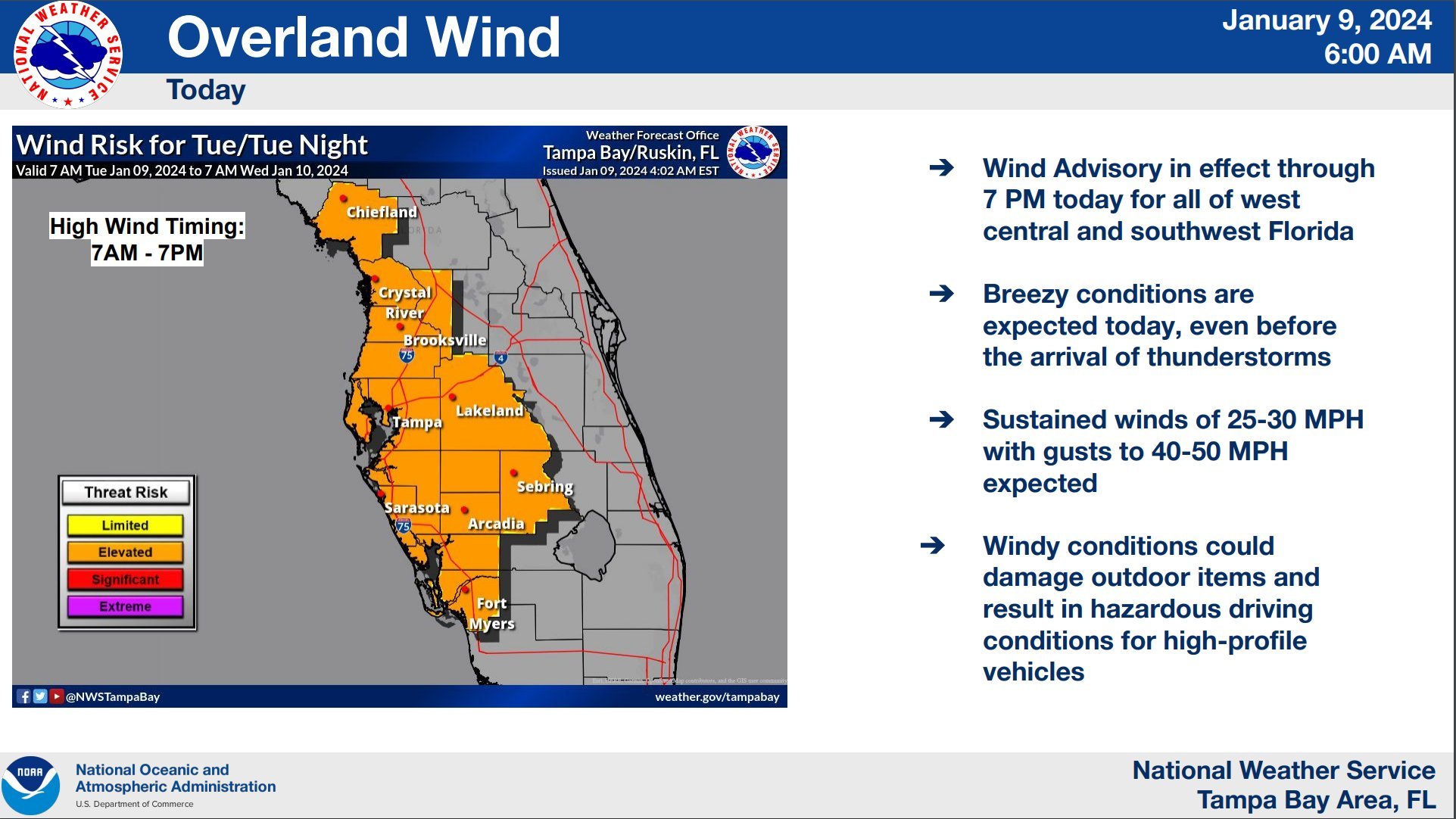
Meteorologists are predicting that the region will experience significant wind gusts tomorrow, even in the absence of any storms. These non-thunderstorm gusts are expected to be quite strong, with some reaching speeds exceeding 40 mph.
Moreover, there's a risk that these thunderstorms could spawn tornadoes, including a few strong EF2+ tornadoes, in the region. When tornadoes are rated as EF2 or higher, it means that they have winds strong enough to cause considerable damage, potentially including the destruction of homes, the uprooting of large trees, and turning debris into dangerous projectiles. In the Tampa Bay area and the Florida peninsula, where strong, long-track tornadoes are rare, EF2 and greater tornadoes can be particularly damaging due to the area’s population density and high number of structures.

A tornado moves through Pinellas County and Clearwater Beach in October 2023. Photo credits: Susan Olds
“The threat for isolated waterspouts and inland tornadoes is markedly higher than we've seen the last few months, even taking into consideration the miniature outbreak we observed on October 11th–12th of last year,” said Nazario.
Meteorologists use a term called "hodographs" to describe the movement and rotation of winds at different levels of the atmosphere. In this case, the presence of large, looping low-level hodographs suggests that tornadoes could form within the line of storms, a phenomenon often referred to as quasi-linear convective system (QLCS) tornadoes.
QLCS tornadoes are a type of tornado that forms within a specific meteorological setup and is characterized by a line of intense thunderstorms. These tornadoes are known to develop rapidly and with little warning, often associated with thunderstorm squall lines. Meteorologists say these tornadoes can “spin up” quickly as part of a larger storm system, making them particularly dangerous due to the short lead time for warnings.
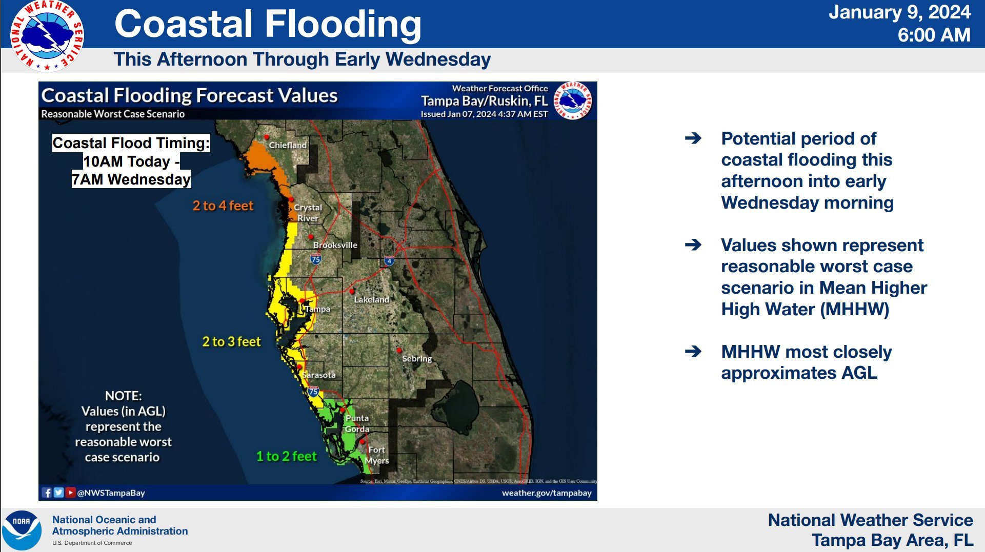
Additionally, major coastal flooding and rip currents are also concerns with this storm system. Parts of Pinellas County, including Clearwater Beach, were flooded following the strong storms that moved through the region in December.
“We're also looking out for coastal flooding, similar to last month. We saw a couple feet of water that came in at some spots last December. That’s another thing the coastal areas should be monitoring,” said Close. “Beyond that, if the storms go on through Wednesday, it could take a while for the surf to come down in some areas, so there will be a high risk of rip currents that will continue through Wednesday and Thursday. It’s safer to stay out of the water if you’re going back to the beach on those days.”
Weather experts also say it's important for those in Tampa Bay and in the region’s outlying counties to stay informed and prepared for Tuesday’s severe weather conditions by having multiple ways to receive weather alerts. The Tampa Bay region has very few outdoor warning sirens so local authorities are encouraging residents and visitors to monitor TV news reports and have emergency alert push notifications enabled on their cell phones. Close also recommends having a NOAA weather radio, which issues severe weather watches and warnings from the NWS.
This is a developing story. Stay tuned to Tampa Bay Living Magazine as any severe weather watches or warnings are issued by the NWS.
Area School Closures and Schedule Changes
Pinellas County Schools will resume normal operations on Tuesday but will mark any absence due to weather-related circumstances as excused. In Gulfport, the Tuesday Fresh Market, Historic Gulfport Casino's Ballroom Dance, and nighttime activities at the Gulfport Recreation Center will be canceled.
Pasco County schools will close, canceling scheduled after-school activities and extracurriculars. The school district plans to reopen schools on Wednesday, with students having a full day of instruction. Pasco-Hernando State College will also close its campuses.
Hernando County schools will have early dismissals, with students released three hours earlier than usual.
The Boys & Girls Club and the YMCA will continue to provide after-school care, while all other after-school activities and events will be canceled. Citrus County schools will be on a half-day schedule, with dismissal times for elementary, middle, and high schools.
Sarasota County Schools will cancel all outdoor after-school activities, while Polk County Public Schools will cancel all after-school activities and sports.
Current Warnings:
Coastal Flood Warning
The Tampa Bay/Ruskin National Weather Service warns of significant coastal flooding in Pinellas, Coastal Levy, Coastal Citrus, Coastal Hernando, Coastal Pasco, Coastal Hillsborough, Coastal Manatee and Coastal Sarasota Counties from 10 a.m. Tuesday to 7 a.m. EST on Wednesday. The event could cause numerous road closures, the inundation of low-lying property and shoreline erosion. Precautionary actions include protecting flood-prone property and avoiding travel around barricades or unknown depths.
Gale Warning
The Tampa Bay/Ruskin National Weather Service has issued a Small Craft Advisory and Gale Warning for the eastern portions of the Gulf of Mexico, including Tampa Bay, Charlotte Harbor and Pine Island Sound. The advisory states strong winds, gusts up to 45 knots, and seas 7 to 10 feet. The warning urges boaters to change their plans, stay in port, seek safe harbor and secure their vessels for severe conditions.

Photo Credits: National Weather Service - Tampa Bay/Ruskin